Geolocate

Hartley topographic map

Click on the map to display elevation.

About this map

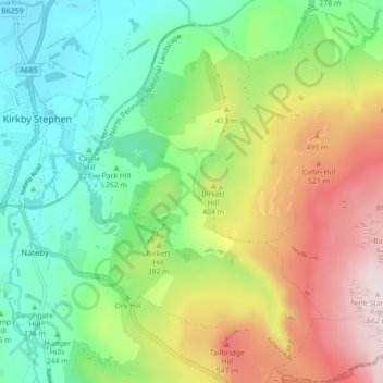
Name: Hartley topographic map, elevation, terrain.

Location: Hartley, Westmorland and Furness, England, United Kingdom (54.43842 -2.35287 54.48906 -2.26537)

Average elevation: 346 m

Minimum elevation: 154 m

Maximum elevation: 661 m

Other topographic maps

Click on a map to view its topography, its elevation and its terrain.

Gear up for your next adventure:

👟Trail Running Shoes - Agile footwear for fast-paced topographic exploration
🔥Camping Stove - Portable stoves to cook outdoors with ease
🌡️Emergency Mylar Blankets - Compact thermal protection for unexpected nights outdoors
🪑Insulated Seat Pad - Protect your seat from cold rocks and wet logs
🕶️Polarized Sunglasses - Protect your eyes with durable polarized lenses

As an Amazon Associate, this site earns from qualifying purchases at no extra cost to you.