
Tripoli topographic map
Click on the map to display elevation.
Tripoli
The urban form of Mamluk Tripoli was dictated mainly by climate, site configuration, defense, and urban aesthetics. The layout of major thoroughfares was set according to prevailing winds and topography. The city had no fortifications, but heavy building construction characterized by compact urban forms, narrow and winding streets for difficult city penetration. Residential areas were bridged over streets at strategic points for surveillance and defense. The city also included many loopholes and narrow slits at street junctions.
About this map
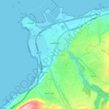
Name: Tripoli topographic map, elevation, terrain.
Location: Tripoli, Tripoli District, North Governorate, 1300, Lebanon (34.39101 35.81776 34.46689 35.87276)
Average elevation: 42 m
Minimum elevation: -3 m
Maximum elevation: 264 m
Other topographic maps
Click on a map to view its topography, its elevation and its terrain.