Geolocate

Cohasset topographic map

Click on the map to display elevation.

About this map

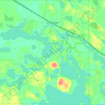
Name: Cohasset topographic map, elevation, terrain.

Location: Cohasset, Itasca County, Minnesota, United States (47.19514 -93.70327 47.28221 -93.57634)

Average elevation: 395 m

Minimum elevation: 378 m

Maximum elevation: 448 m

Other topographic maps

Click on a map to view its topography, its elevation and its terrain.

Upper Twin Lakes

United States > Minnesota > Itasca County > Rosy

Average elevation: 409 m

Togo

United States > Minnesota > Itasca County

Average elevation: 408 m

Candy Lake

United States > Minnesota > Itasca County

Average elevation: 421 m

Gear up for your next adventure:

🚲Heavy Duty Bike Lock - Secure your bike at the trailhead or during stops
🧤Thermal Hiking Gloves - Grip-enhanced gloves for cold-weather altitude trekking
🚲Bike Repair Kit - Essential tools for on-trail mechanical issues
🌡️Emergency Mylar Blankets - Compact thermal protection for unexpected nights outdoors
🧥Packable Rain Jacket - Breathable waterproof layer for unpredictable weather

As an Amazon Associate, this site earns from qualifying purchases at no extra cost to you.