
Make a donation
Gear up for your next adventure:
As an Amazon Associate, this site earns from qualifying purchases at no extra cost to you.
South Tyrol topographic map
Click on the map to display elevation.
Make a donation
Gear up for your next adventure:
As an Amazon Associate, this site earns from qualifying purchases at no extra cost to you.
South Tyrol
Although some isolated massifs approach 4,000 metres (13,000 ft) and show strong glaciation (especially in the Ortler Alps and on the main ridge of the Alps), South Tyrol is by far dominated by mountains with altitudes of between 2,000 and 3,000 metres (6,600 and 9,800 ft). Among the multitude of peaks, the Dolomites are the highest in the Alps. Among the large number of peaks, three stand out for their alpine or cultural importance: the Ortler (3,905 metres, 12,812 ft) as the highest mountain in South Tyrol, the Schlern (2,563 metres, 8,409 ft) as the country's "landmark" and the Drei Zinnen (2,999 metres, 9,839 ft) as the center of alpine climbing. Other well-known mountains are the Königspitze (3,851 metres, 12,635 ft), the Weißkugel (3,739 metres, 12,267 ft), the Similaun (3,599 metres, 11,808 ft), the Hochwilde (3,480 metres, 11,417 ft), the Sarner Weißhorn (2,705 metres, 8,875 ft), the Hochfeiler (3,509 metres, 11,512 ft), the Dreiherrnspitze (3,499 metres, 11,480 ft), the Hochgall (3,436 metres, 11,273 ft), the Peitlerkofel (2,875 metres, 9,432 ft), the Langkofel (3,181 metres, 10,436 ft) and the Rosengartenspitze (2,981 metres, 9,780 ft).
Make a donation
Gear up for your next adventure:
As an Amazon Associate, this site earns from qualifying purchases at no extra cost to you.
About this map
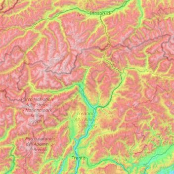
Name: South Tyrol topographic map, elevation, terrain.
Location: South Tyrol, Trentino – Alto Adige/Südtirol, Italy (46.21977 10.38180 47.09215 12.47797)
Average elevation: 1,725 m
Minimum elevation: 159 m
Maximum elevation: 3,832 m
Make a donation
Gear up for your next adventure:
As an Amazon Associate, this site earns from qualifying purchases at no extra cost to you.
Other topographic maps
Click on a map to view its topography, its elevation and its terrain.
Froi - Froia
Italy > Trentino – Alto Adige/Südtirol > South Tyrol > Graun - Curon Venosta
Average elevation: 1,785 m
Make a donation
Gear up for your next adventure:
As an Amazon Associate, this site earns from qualifying purchases at no extra cost to you.
Secëda - Monte Seceda
Italy > Trentino – Alto Adige/Südtirol > South Tyrol > Santa Cristina Gherdëina - St. Christina in Gröden - Santa Cristina Valgardena
Monte Seceda is a 2,519-meter-elevation (8,264-foot) summit in the Odles Group of the Dolomites, a UNESCO World Heritage Site. Set in the Trentino-Alto Adige/Südtirol region, the peak is located four kilometers (2.5 miles) north of the village of Santa Cristina Gherdëina, and the peak is in Puez-Geisler…
Average elevation: 2,106 m
Gherdëina - Grödnertal - Val Gardena
Italy > Trentino – Alto Adige/Südtirol > South Tyrol > Urtijëi - St. Ulrich in Gröden - Ortisei
Average elevation: 1,607 m
Welsberg - Monguelfo
Italy > Trentino – Alto Adige/Südtirol > South Tyrol > Welsberg-Taisten - Monguelfo-Tesido
Average elevation: 1,289 m
Make a donation
Gear up for your next adventure:
As an Amazon Associate, this site earns from qualifying purchases at no extra cost to you.
Val di Fiemme
Italy > Trentino – Alto Adige/Südtirol > Provincia di Trento > Panchià
Average elevation: 1,640 m
Schlern - Sciliar
Italy > Trentino – Alto Adige/Südtirol > South Tyrol > Völs am Schlern - Fiè allo Sciliar
Average elevation: 2,033 m
Gufidaun - Gudon
Italy > Trentino – Alto Adige/Südtirol > South Tyrol > Klausen - Chiusa
Average elevation: 860 m
Make a donation
Gear up for your next adventure:
As an Amazon Associate, this site earns from qualifying purchases at no extra cost to you.
Secëda - Monte Seceda
Italy > Trentino – Alto Adige/Südtirol > South Tyrol > Santa Cristina Gherdëina - St. Christina in Gröden - Santa Cristina Valgardena
Monte Seceda is a 2,519-meter-elevation (8,264-foot) summit in the Odles Group of the Dolomites, a UNESCO World Heritage Site. Set in the Trentino-Alto Adige/Südtirol region, the peak is located four kilometers (2.5 miles) north of the village of Santa Cristina Gherdëina, and the peak is in Puez-Geisler…
Average elevation: 2,106 m
Sulden - Solda
Italy > Trentino – Alto Adige/Südtirol > South Tyrol > Stilfs - Stelvio
Average elevation: 2,232 m
Make a donation
Gear up for your next adventure:
As an Amazon Associate, this site earns from qualifying purchases at no extra cost to you.
Siebeneich - Settequerce
Italy > Trentino – Alto Adige/Südtirol > South Tyrol
Average elevation: 427 m
Langtauferer Tal - Vallelunga
Italy > Trentino – Alto Adige/Südtirol > South Tyrol > Graun - Curon Venosta
Average elevation: 2,513 m
Obereggen - San Floriano d'Ega
Italy > Trentino – Alto Adige/Südtirol > South Tyrol > Deutschnofen - Nova Ponente
Average elevation: 1,650 m
Flading - Vallettina
Italy > Trentino – Alto Adige/Südtirol > South Tyrol > Ratschings - Racines
Average elevation: 2,012 m
Make a donation
Gear up for your next adventure:
As an Amazon Associate, this site earns from qualifying purchases at no extra cost to you.
Funtanacia
Italy > Trentino – Alto Adige/Südtirol > South Tyrol > La Ila - Stern - La Villa
Average elevation: 1,787 m
Make a donation
Gear up for your next adventure:
As an Amazon Associate, this site earns from qualifying purchases at no extra cost to you.
Mitterdorf - Caldaro di Mezzo
Italy > Trentino – Alto Adige/Südtirol > South Tyrol > St. Nikolaus - San Nicolò
Average elevation: 664 m
Grünsee - Lago Verde
Italy > Trentino – Alto Adige/Südtirol > South Tyrol > Ulten - Ultimo
Average elevation: 2,683 m
Cortina
Italy > Trentino – Alto Adige/Südtirol > Provincia di Trento > Vermiglio
Average elevation: 1,534 m
Make a donation
Gear up for your next adventure:
As an Amazon Associate, this site earns from qualifying purchases at no extra cost to you.
Schmieden - Ferrara
Italy > Trentino – Alto Adige/Südtirol > South Tyrol > Prags - Braies
Average elevation: 1,426 m
Covelo
Italy > Trentino – Alto Adige/Südtirol > Provincia di Trento > Vallelaghi
Average elevation: 834 m
Antlas
Italy > Trentino – Alto Adige/Südtirol > South Tyrol > Ritten - Renon > Atzwang - Campodazzo
Average elevation: 818 m
Make a donation
Gear up for your next adventure:
As an Amazon Associate, this site earns from qualifying purchases at no extra cost to you.
Nock
Italy > Trentino – Alto Adige/Südtirol > South Tyrol > Ratschings - Racines
Average elevation: 1,795 m
Tierseralpl - Alpe di Tires
Italy > Trentino – Alto Adige/Südtirol > South Tyrol > Tiers - Tires
Average elevation: 2,285 m
Make a donation
Gear up for your next adventure:
As an Amazon Associate, this site earns from qualifying purchases at no extra cost to you.
Schluderbach - Carbonin
Italy > Trentino – Alto Adige/Südtirol > South Tyrol > Toblach - Dobbiaco
Average elevation: 1,776 m
Antermëia - Untermoi - Antermoia
Italy > Trentino – Alto Adige/Südtirol > South Tyrol > San Martin de Tor - San Martino in Badia - St. Martin in Thurn
Average elevation: 1,677 m
St. Georg - San Giorgio di Eores
Italy > Trentino – Alto Adige/Südtirol > South Tyrol > Brixen - Bressanone
Average elevation: 1,476 m
Make a donation
Gear up for your next adventure:
As an Amazon Associate, this site earns from qualifying purchases at no extra cost to you.
St. Anton - Sant'Antonio
Italy > Trentino – Alto Adige/Südtirol > South Tyrol > St. Nikolaus - San Nicolò
Average elevation: 745 m
Lago di Molveno
Italy > Trentino – Alto Adige/Südtirol > Provincia di Trento > Molveno
Average elevation: 1,071 m
Make a donation
Gear up for your next adventure:
As an Amazon Associate, this site earns from qualifying purchases at no extra cost to you.
Schneespitz - Cima della Neve
Italy > Trentino – Alto Adige/Südtirol > South Tyrol > Predoi
Average elevation: 2,497 m
Costadedoi
Italy > Trentino – Alto Adige/Südtirol > South Tyrol > San Ćiascian - St. Kassian - San Cassiano
Average elevation: 1,712 m
Make a donation
Gear up for your next adventure:
As an Amazon Associate, this site earns from qualifying purchases at no extra cost to you.
Obereggen - San Floriano d'Ega
Italy > Trentino – Alto Adige/Südtirol > South Tyrol > Deutschnofen - Nova Ponente
Average elevation: 1,650 m
St. Magdalena - Santa Maddalena in Casies
Italy > Trentino – Alto Adige/Südtirol > South Tyrol > Gsies - Valle di Casies
Average elevation: 1,772 m
Croda del Becco - Sas dla Porta - Seekofel
Italy > Trentino – Alto Adige/Südtirol > South Tyrol > Prags - Braies
Average elevation: 2,186 m
Make a donation
Gear up for your next adventure:
As an Amazon Associate, this site earns from qualifying purchases at no extra cost to you.
Bocca di Valle
Italy > Trentino – Alto Adige/Südtirol > Provincia di Trento > Bondone
Average elevation: 1,258 m
Alpe Cermis
Italy > Trentino – Alto Adige/Südtirol > Provincia di Trento > Cavalese
Average elevation: 1,715 m
Make a donation
Gear up for your next adventure:
As an Amazon Associate, this site earns from qualifying purchases at no extra cost to you.
Al Plan de Mareo - St. Vigil in Enneberg - San Vigilio di Marebbe
Italy > Trentino – Alto Adige/Südtirol > South Tyrol > Marèo - Enneberg - Marebbe
Average elevation: 1,407 m
Ronchi
Italy > Trentino – Alto Adige/Südtirol > Provincia di Trento > Trento > Mattarello
Average elevation: 339 m
Belvedere
Italy > Trentino – Alto Adige/Südtirol > Provincia di Trento > Pergine Valsugana
Average elevation: 791 m
Madonna di Campiglio
Italy > Trentino – Alto Adige/Südtirol > Provincia di Trento
Madonna di Campiglio (German: Sankt Maria im Pein) is a village and a ski resort in northeast Italy. It is a frazione of the comune of Pinzolo. The village lies in the Val Rendena at an elevation of 1,522 m (4,993 ft) above sea level, and has approximately 1,000 inhabitants.
Average elevation: 1,744 m
Make a donation
Gear up for your next adventure:
As an Amazon Associate, this site earns from qualifying purchases at no extra cost to you.
Lengmoos - Longomoso
Italy > Trentino – Alto Adige/Südtirol > South Tyrol > Ritten - Renon > Klobenstein - Collalbo
Average elevation: 1,049 m
Make a donation
Gear up for your next adventure:
As an Amazon Associate, this site earns from qualifying purchases at no extra cost to you.
Hoher Weißzint - Punta Bianca
Italy > Trentino – Alto Adige/Südtirol > South Tyrol > Mühlwald - Selva dei Molini
Average elevation: 2,905 m
Turnerkamp - Cima di Campo
Italy > Trentino – Alto Adige/Südtirol > South Tyrol > Mühlwald - Selva dei Molini
Average elevation: 2,868 m
Make a donation
Gear up for your next adventure:
As an Amazon Associate, this site earns from qualifying purchases at no extra cost to you.
St. Anton - Sant'Antonio
Italy > Trentino – Alto Adige/Südtirol > South Tyrol > St. Nikolaus - San Nicolò
Average elevation: 745 m
Ortler - Ortles
Italy > Trentino – Alto Adige/Südtirol > South Tyrol > Stilfs - Stelvio
The Ortler was first climbed by Josef Pichler [de] ("Pseirer-Josele"), a chamois hunter from St. Leonhard in Passeier, and his companions Johann Leitner and Johann Klausner from Zell am Ziller on 27 September 1804. The ascent had been a request of Archduke Johann of Austria, who felt strongly that after the…
Average elevation: 3,175 m
Sulden - Solda
Italy > Trentino – Alto Adige/Südtirol > South Tyrol > Stilfs - Stelvio
Average elevation: 2,232 m
Make a donation
Gear up for your next adventure:
As an Amazon Associate, this site earns from qualifying purchases at no extra cost to you.
Atzwang - Campodazzo
Italy > Trentino – Alto Adige/Südtirol > South Tyrol > Ritten - Renon
Average elevation: 786 m
Grube - Fossa
Italy > Trentino – Alto Adige/Südtirol > South Tyrol > Oberradein - Redagno di Sopra
Average elevation: 1,477 m
Make a donation
Gear up for your next adventure:
As an Amazon Associate, this site earns from qualifying purchases at no extra cost to you.
Valsorda
Italy > Trentino – Alto Adige/Südtirol > Provincia di Trento > Predazzo
Average elevation: 1,785 m
Pinzon - Pinzano
Italy > Trentino – Alto Adige/Südtirol > South Tyrol > Montan an der Weinstraße - Montagna sulla Strada del Vino
Average elevation: 524 m
Make a donation
Gear up for your next adventure:
As an Amazon Associate, this site earns from qualifying purchases at no extra cost to you.
Biacesa di Ledro
Italy > Trentino – Alto Adige/Südtirol > Provincia di Trento
Average elevation: 831 m
Roen
Italy > Trentino – Alto Adige/Südtirol > South Tyrol > Tramin an der Weinstraße - Termeno sulla Strada del Vino
Average elevation: 1,740 m
Maring
Italy > Trentino – Alto Adige/Südtirol > South Tyrol > La Ila - Stern - La Villa
Average elevation: 1,727 m
Villa Nöia
Italy > Trentino – Alto Adige/Südtirol > South Tyrol > La Ila - Stern - La Villa
Average elevation: 1,632 m
Make a donation
Gear up for your next adventure:
As an Amazon Associate, this site earns from qualifying purchases at no extra cost to you.
Cortina
Italy > Trentino – Alto Adige/Südtirol > Provincia di Trento > Vermiglio
Average elevation: 1,534 m
Graun im Vinschgau - Curon Venosta
Italy > Trentino – Alto Adige/Südtirol > South Tyrol > Graun - Curon Venosta
Average elevation: 1,794 m
Saone
Italy > Trentino – Alto Adige/Südtirol > Provincia di Trento > Tione di Trento
Average elevation: 848 m
Make a donation
Gear up for your next adventure:
As an Amazon Associate, this site earns from qualifying purchases at no extra cost to you.
Karerpass - Jouf de Ciareja - passo Carezza
Italy > Trentino – Alto Adige/Südtirol > Provincia di Trento
Average elevation: 1,869 m
Dossone
Italy > Trentino – Alto Adige/Südtirol > Provincia di Trento > Caderzone Terme
Average elevation: 1,639 m
Kühwiesenkopf - Monte Prà della Vacca
Italy > Trentino – Alto Adige/Südtirol > South Tyrol > Prags - Braies
Average elevation: 1,854 m
Camin
Italy > Trentino – Alto Adige/Südtirol > Provincia di Trento > Ziano di Fiemme
Average elevation: 2,022 m
Make a donation
Gear up for your next adventure:
As an Amazon Associate, this site earns from qualifying purchases at no extra cost to you.
Lago di Lagolo
Italy > Trentino – Alto Adige/Südtirol > Provincia di Trento > Lagolo
Average elevation: 1,004 m
Carbonare
Italy > Trentino – Alto Adige/Südtirol > Provincia di Trento > San Sebastiano
Average elevation: 1,167 m
Seis am Schlern - Siusi allo Sciliar
Italy > Trentino – Alto Adige/Südtirol > South Tyrol > Kastelruth - Castelrotto
Average elevation: 1,211 m
Make a donation
Gear up for your next adventure:
As an Amazon Associate, this site earns from qualifying purchases at no extra cost to you.
Thal
Italy > Trentino – Alto Adige/Südtirol > South Tyrol > Martell - Martello
Average elevation: 1,726 m
Reschen - Resia
Italy > Trentino – Alto Adige/Südtirol > South Tyrol > Graun - Curon Venosta
Average elevation: 1,814 m
Bergner Kreuz - Croce di Forcella Piccola
Italy > Trentino – Alto Adige/Südtirol > Provincia di Trento
Average elevation: 1,433 m
Make a donation
Gear up for your next adventure:
As an Amazon Associate, this site earns from qualifying purchases at no extra cost to you.