
Make a donation
Gear up for your next adventure:
As an Amazon Associate, this site earns from qualifying purchases at no extra cost to you.
Beckingen topographic map
Click on the map to display elevation.
Make a donation
Gear up for your next adventure:
As an Amazon Associate, this site earns from qualifying purchases at no extra cost to you.
About this map
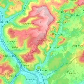
Name: Beckingen topographic map, elevation, terrain.
Location: Beckingen, Landkreis Merzig-Wadern, Saarland, 66701, Deutschland (49.37213 6.66302 49.46723 6.80218)
Average elevation: 268 m
Minimum elevation: 164 m
Maximum elevation: 424 m
Make a donation
Gear up for your next adventure:
As an Amazon Associate, this site earns from qualifying purchases at no extra cost to you.
Other topographic maps
Click on a map to view its topography, its elevation and its terrain.
Make a donation
Gear up for your next adventure:
As an Amazon Associate, this site earns from qualifying purchases at no extra cost to you.
Stausee Losheim
Deutschland > Saarland > Landkreis Merzig-Wadern > Losheim am See
Average elevation: 331 m
Make a donation
Gear up for your next adventure:
As an Amazon Associate, this site earns from qualifying purchases at no extra cost to you.
Naturschutzgebiet Wadrilltal
Deutschland > Saarland > Landkreis Merzig-Wadern > Wadern
Average elevation: 323 m
Make a donation
Gear up for your next adventure:
As an Amazon Associate, this site earns from qualifying purchases at no extra cost to you.
Reidelbach
Deutschland > Saarland > Landkreis Merzig-Wadern > Wadern > Wedern
Average elevation: 395 m
Scheiden
Deutschland > Saarland > Landkreis Merzig-Wadern > Losheim am See > Scheiden
Average elevation: 473 m
Make a donation
Gear up for your next adventure:
As an Amazon Associate, this site earns from qualifying purchases at no extra cost to you.
Rissenthal
Deutschland > Saarland > Landkreis Merzig-Wadern > Losheim am See > Rissenthal
Average elevation: 305 m