
Make a donation
Gear up for your next adventure:
As an Amazon Associate, this site earns from qualifying purchases at no extra cost to you.
Wahlen topographic map
Click on the map to display elevation.
Make a donation
Gear up for your next adventure:
As an Amazon Associate, this site earns from qualifying purchases at no extra cost to you.
About this map
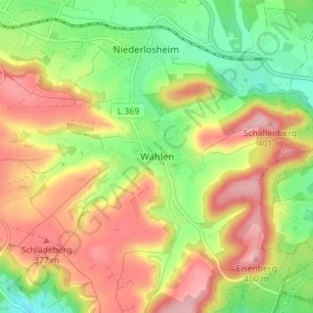
Name: Wahlen topographic map, elevation, terrain.
Average elevation: 323 m
Minimum elevation: 245 m
Maximum elevation: 402 m
Make a donation
Gear up for your next adventure:
As an Amazon Associate, this site earns from qualifying purchases at no extra cost to you.
Other topographic maps
Click on a map to view its topography, its elevation and its terrain.
Niederlosheim
Deutschland > Saarland > Landkreis Merzig-Wadern > Losheim am See
Average elevation: 313 m
Stausee Losheim
Deutschland > Saarland > Landkreis Merzig-Wadern > Losheim am See
Average elevation: 331 m
Make a donation
Gear up for your next adventure:
As an Amazon Associate, this site earns from qualifying purchases at no extra cost to you.
Waldhölzbach
Deutschland > Saarland > Landkreis Merzig-Wadern > Losheim am See
Average elevation: 440 m
Rissenthal
Deutschland > Saarland > Landkreis Merzig-Wadern > Losheim am See
Rissenthal liegt an einem südlichen Ausläufer des Schwarzwälder Hochwaldes, in einem Seitental des Oberen Haustadter Tales, südsüdöstlich vom Kern der Gemeinde Losheim. Die durchschnittliche Höhe liegt bei 250 m ü. NHN. Die das Dorf umgebenden Höhen erreichen mit dem Schlädberg auf 382 m ü. NHN die…
Average elevation: 316 m
Make a donation
Gear up for your next adventure:
As an Amazon Associate, this site earns from qualifying purchases at no extra cost to you.
Make a donation
Gear up for your next adventure:
As an Amazon Associate, this site earns from qualifying purchases at no extra cost to you.