Geolocate

Redwater topographic map

Click on the map to display elevation.

About this map

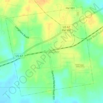
Name: Redwater topographic map, elevation, terrain.

Location: Redwater, Bowie County, Texas, 75573, United States (33.34651 -94.26885 33.36996 -94.24122)

Average elevation: 87 m

Minimum elevation: 72 m

Maximum elevation: 104 m

Other topographic maps

Click on a map to view its topography, its elevation and its terrain.

Old Salem

United States > Texas > Bowie County

Average elevation: 110 m

Eylau

United States > Texas > Bowie County

Average elevation: 93 m

Eylau

United States > Texas > Bowie County

Average elevation: 93 m

Gear up for your next adventure:

🧢Outdoor Visor - Breathable visor for sunny hikes
💧Hydration Bladder - Hands-free hydration solution for long treks
🥾Light Trekking Boots - Supportive boots for multi-day treks
💧Reusable Water Bottle - Durable water bottles for hydration on trails
🧦Outdoor Socks - Durable socks designed for hiking and outdoor sports

As an Amazon Associate, this site earns from qualifying purchases at no extra cost to you.