Geolocate

Nargoli topographic map

Click on the map to display elevation.

About this map

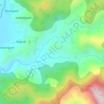
Name: Nargoli topographic map, elevation, terrain.

Location: Nargoli, Kanda, Bageshwar District, Uttarakhand, India (29.78445 79.99690 29.78618 80.00346)

Average elevation: 1,344 m

Minimum elevation: 1,162 m

Maximum elevation: 1,755 m

Other topographic maps

Click on a map to view its topography, its elevation and its terrain.

taknar

India > Uttarakhand > Kanda > taknar

Average elevation: 1,545 m

banegaon

India > Uttarakhand > Kanda > banegaon

Average elevation: 1,356 m

Gear up for your next adventure:

🧤Rechargeable Heated Gloves - Extreme warmth for Canadian winter expeditions
🧥Softshell Jacket - Windproof and breathable jacket for hiking
🥾Trekking Boots - Durable boots for long-distance trekking
🥾Trail Running Shoes - Lightweight and durable shoes for trail running
🧢Outdoor Visor - Breathable visor for sunny hikes

As an Amazon Associate, this site earns from qualifying purchases at no extra cost to you.