
Uxbridge topographic map
Interactive map
Click on the map to display elevation.
About this map
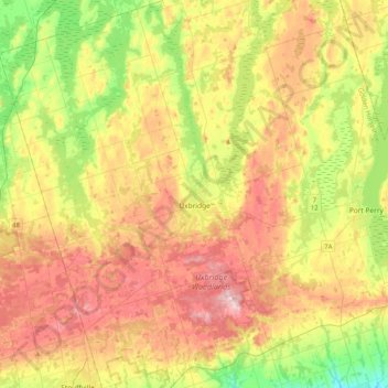
Name: Uxbridge topographic map, elevation, terrain.
Location: Uxbridge, Durham Region, Golden Horseshoe, Ontario, Canada (43.97092 -79.32799 44.26317 -79.04801)
Average elevation: 284 m
Minimum elevation: 177 m
Maximum elevation: 403 m
Durham Region trails, hiking, mountain biking, running and outdoor activities
Other topographic maps
Click on a map to view its topography, its elevation and its terrain.
Darlington Provincial Park
Canada > Ontario > Durham Region > Clarington
Darlington Provincial Park is a provincial park in Ontario, Canada. It is located just south of Highway 401 in the city of Bowmanville. A small park, the topography is dominated by gentle hills formed by a terminal moraine deposited by glaciers at the end of the last Ice Age. The park borders on the northern…
Average elevation: 84 m