
Myrtle topographic map
Interactive map
Click on the map to display elevation.
About this map
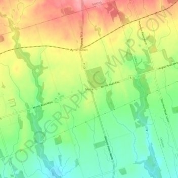
Name: Myrtle topographic map, elevation, terrain.
Average elevation: 252 m
Minimum elevation: 201 m
Maximum elevation: 312 m
Other topographic maps
Click on a map to view its topography, its elevation and its terrain.
Corbett Creek
Canada > Ontario > Durham Region > Whitby
Corbett Creek, Whitby, Durham Region, Golden Horseshoe, Ontario, L1J 6W7, Canada
Average elevation: 101 m
Corbett Creek
Canada > Ontario > Durham Region > Whitby
Corbett Creek, Whitby, Durham Region, Golden Horseshoe, Ontario, Canada
Average elevation: 83 m