
Make a donation
North Bay topographic map
Interactive map
Click on the map to display elevation.


North Bay
The climate in North Bay is common to most places in Northern Ontario. North Bay tends to be a less humid climate than that found in Southern Ontario due somewhat to the distance from the Great Lakes and less warm than some other locations in Northern Ontario due to cooling from Lake Nipissing. On May 31, 2002, a tornado caused minor damage near the city. Two more tornadoes touched down on Lake Nipissing on August 20, 2009. This storm was a part of a chain of tornadoes that caused large amounts of damage in other parts of Ontario. The weather box below shows climate normals for the airport, at an elevation of 358 m, but the majority of the city, including the downtown core, sits at an elevation of 201 m.
About this map
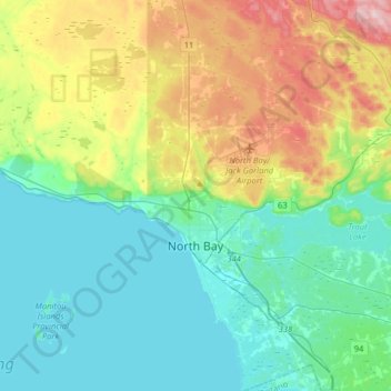
Name: North Bay topographic map, elevation, terrain.
Average elevation: 266 m
Minimum elevation: 190 m
Maximum elevation: 472 m
Nipissing District trails, hiking, mountain biking, running and outdoor activities
Other topographic maps
Click on a map to view its topography, its elevation and its terrain.
Windermere Lake
Canada > Ontario > Nipissing District > Unorganized South Nipissing
Average elevation: 355 m
Arrow Lake
Canada > Ontario > Nipissing District > Unorganized South Nipissing
Average elevation: 414 m
Thistle Lake
Canada > Ontario > Nipissing District > Unorganized South Nipissing
Average elevation: 459 m
William Lake
Canada > Ontario > Nipissing District > Unorganized South Nipissing
Average elevation: 421 m
Gilmour Lake
Canada > Ontario > Nipissing District > Papineau-Cameron Township
Average elevation: 342 m
Smoke Lake
Canada > Ontario > Nipissing District > Unorganized South Nipissing
Average elevation: 439 m
Carcajou Lake
Canada > Ontario > Nipissing District > Unorganized South Nipissing
Average elevation: 291 m
Bellwood
Canada > Ontario > Nipissing District > South Algonquin Township > Whitney
Average elevation: 410 m
Rose Lake
Canada > Ontario > Nipissing District > Unorganized South Nipissing
Average elevation: 459 m
Beau Lake
Canada > Ontario > Nipissing District > Unorganized South Nipissing
Average elevation: 416 m
Coldspring Lake
Canada > Ontario > Nipissing District > Unorganized South Nipissing
Average elevation: 440 m
Madawaska Highlands
Canada > Ontario > Nipissing District > South Algonquin Township
Average elevation: 442 m
Gilmour Island
Canada > Ontario > Nipissing District > Unorganized South Nipissing
Average elevation: 339 m
Head Lake
Canada > Ontario > Nipissing District > Unorganized South Nipissing
Average elevation: 445 m
Mizzy Lake
Canada > Ontario > Nipissing District > Unorganized South Nipissing
Average elevation: 459 m
Rutherglen
Canada > Ontario > Nipissing District > Bonfield Township > Rutherglen
Average elevation: 236 m
Princes Lake
Canada > Ontario > Nipissing District > South Algonquin Township
Average elevation: 467 m
Whitelily Lake
Canada > Ontario > Nipissing District > South Algonquin Township
Average elevation: 389 m