
Cape Breton Highlands National Park topographic map
Interactive map
Click on the map to display elevation.
About this map
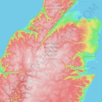
Name: Cape Breton Highlands National Park topographic map, elevation, terrain.
Average elevation: 265 m
Minimum elevation: -2 m
Maximum elevation: 531 m
Cape Breton Highlands National Park trails, hiking, mountain biking, running and outdoor activities
Other topographic maps
Click on a map to view its topography, its elevation and its terrain.
White Hill
Canada > Nova Scotia > Cape Breton Highlands National Park > Cape Breton Highlands National Park
White Hill is a peak in the Cape Breton Highlands and is the highest elevation point in the province of Nova Scotia, Canada.
Average elevation: 488 m