
Waterton Park topographic map
Interactive map
Click on the map to display elevation.
Waterton Park
It is located at the southwestern terminus of Highway 5, approximately 54 kilometres (34 mi) west of the Town of Cardston and 55 kilometres (34 mi) south of the Town of Pincher Creek. This hamlet is north of Glacier National Park in Montana. It has an elevation of 1,280 metres (4,200 ft).
About this map
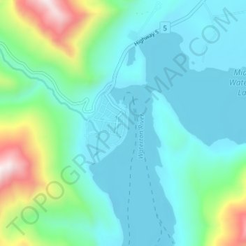
Name: Waterton Park topographic map, elevation, terrain.
Average elevation: 1,456 m
Minimum elevation: 1,269 m
Maximum elevation: 2,207 m
Improvement District No. 04 trails, hiking, mountain biking, running and outdoor activities
Other topographic maps
Click on a map to view its topography, its elevation and its terrain.