
Area A (Kyuquot/Nootka/Sayward) topographic map
Interactive map
Click on the map to display elevation.
About this map
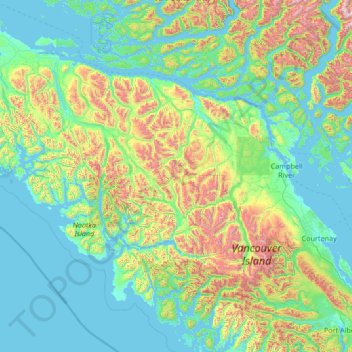
Name: Area A (Kyuquot/Nootka/Sayward) topographic map, elevation, terrain.
Average elevation: 390 m
Minimum elevation: -1 m
Maximum elevation: 2,509 m
Strathcona Regional District trails, hiking, mountain biking, running and outdoor activities
Other topographic maps
Click on a map to view its topography, its elevation and its terrain.
Ripple Rock
Canada > British Columbia > Strathcona Regional District > Area B (Discovery Islands/Mainland Inlets)
Average elevation: 40 m
Mount Hayes
Canada > British Columbia > Strathcona Regional District > Area B (Discovery Islands/Mainland Inlets)
Average elevation: 1,101 m
Cachalot
Canada > British Columbia > Strathcona Regional District > Area A (Kyuquot/Nootka/Sayward)
Average elevation: 386 m
Whiteley Island
Canada > British Columbia > Strathcona Regional District > Area A (Kyuquot/Nootka/Sayward)
Average elevation: 16 m
Whaletown
Canada > British Columbia > Strathcona Regional District > Area C (Cortes Island)
Average elevation: 26 m
Protection Island
Canada > British Columbia > Strathcona Regional District > Area C (Cortes Island)
Average elevation: 36 m
John Hart Dam
Canada > British Columbia > Strathcona Regional District > Campbell River
Average elevation: 155 m
Elk Falls Viewing Platform
Canada > British Columbia > Strathcona Regional District > Campbell River
Average elevation: 137 m
Wolf Mountain
Canada > British Columbia > Strathcona Regional District > Area D (Oyster Bay/Buttle Lake)
Average elevation: 1,254 m
Upana Caves
Canada > British Columbia > Strathcona Regional District > Area A (Kyuquot/Nootka/Sayward)
Average elevation: 684 m
Oyster River
Canada > British Columbia > Strathcona Regional District > Area D (Oyster Bay/Buttle Lake) > Oyster River
Average elevation: 24 m
Mount Bute
Canada > British Columbia > Strathcona Regional District > Area B (Discovery Islands/Mainland Inlets)
Average elevation: 1,993 m
Arnica Lake
Canada > British Columbia > Strathcona Regional District > Area D (Oyster Bay/Buttle Lake)
Average elevation: 1,180 m
Flower Ridge
Canada > British Columbia > Strathcona Regional District > Area D (Oyster Bay/Buttle Lake)
Average elevation: 1,095 m
Kings Peak
Canada > British Columbia > Strathcona Regional District > Area D (Oyster Bay/Buttle Lake)
Average elevation: 1,435 m
Broken Islands
Canada > British Columbia > Strathcona Regional District > Area B (Discovery Islands/Mainland Inlets)
Average elevation: 10 m
Victor Island
Canada > British Columbia > Strathcona Regional District > Area A (Kyuquot/Nootka/Sayward)
Average elevation: 26 m
Duncan Bay
Canada > British Columbia > Strathcona Regional District > Campbell River
Average elevation: 18 m
Tahsis
Canada > British Columbia > Strathcona Regional District > Tahsis > Tahsis
Average elevation: 252 m