
Elk Falls Viewing Platform topographic map
Click on the map to display elevation.
About this map
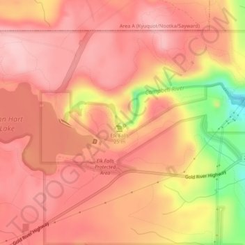
Name: Elk Falls Viewing Platform topographic map, elevation, terrain.
Average elevation: 137 m
Minimum elevation: 14 m
Maximum elevation: 183 m
Strathcona Regional District trails, hiking, mountain biking, running and outdoor activities
Other topographic maps
Click on a map to view its topography, its elevation and its terrain.
John Hart Dam
Canada > British Columbia > Strathcona Regional District > Campbell River
Average elevation: 155 m
Elk Falls Provincial Park
Canada > British Columbia > Strathcona Regional District > Campbell River
Average elevation: 96 m
John Hart Lake
Canada > British Columbia > Strathcona Regional District > Campbell River
Average elevation: 161 m