
Cobourg topographic map
Interactive map
Click on the map to display elevation.


About this map
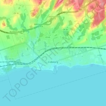
Name: Cobourg topographic map, elevation, terrain.
Average elevation: 94 m
Minimum elevation: 70 m
Maximum elevation: 169 m
Northumberland County trails, hiking, mountain biking, running and outdoor activities
Other topographic maps
Click on a map to view its topography, its elevation and its terrain.
Ferris Provincial Park
Canada > Ontario > Northumberland County > Trent Hills > Campbellford
Average elevation: 151 m
Trent River
Canada > Ontario > Northumberland County > Trent Hills > Trent River
Average elevation: 197 m
Camborne
Canada > Ontario > Northumberland County > Hamilton Township > Camborne
Average elevation: 196 m