
Burnley Creek topographic map
Interactive map
Click on the map to display elevation.
About this map
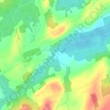
Name: Burnley Creek topographic map, elevation, terrain.
Average elevation: 213 m
Minimum elevation: 178 m
Maximum elevation: 269 m
Other topographic maps
Click on a map to view its topography, its elevation and its terrain.
Trent River
Canada > Ontario > Northumberland County > Trent Hills
Trent River, Trent Hills, Northumberland County, Central Ontario, Ontario, K0L 1L0, Canada
Average elevation: 138 m
Pethericks Corners
Canada > Ontario > Northumberland County > Trent Hills
Pethericks Corners, Trent Hills, Northumberland County, Central Ontario, Ontario, Canada
Average elevation: 181 m
Ferris Provincial Park
Canada > Ontario > Northumberland County > Trent Hills > Campbellford
Ferris Provincial Park, Campbellford, Trent Hills, Northumberland County, Central Ontario, Ontario, Canada
Average elevation: 151 m
Campbellford
Canada > Ontario > Northumberland County > Trent Hills
Campbellford, Trent Hills, Northumberland County, Central Ontario, Ontario, K0L 1L0, Canada
Average elevation: 174 m
Hastings
Canada > Ontario > Northumberland County > Trent Hills
Hastings, Trent Hills, Northumberland County, Central Ontario, Ontario, K0L 1Y0, Canada
Average elevation: 207 m
Warkworth
Canada > Ontario > Northumberland County > Trent Hills
Warkworth, Trent Hills, Northumberland County, Central Ontario, Ontario, K0K 3K0, Canada
Average elevation: 165 m
Trent River
Canada > Ontario > Northumberland County > Trent Hills > Trent River
Trent River, Trent Hills, Northumberland County, Central Ontario, Ontario, K0L 1Z0, Canada
Average elevation: 197 m
Hardy Island
Canada > Ontario > Northumberland County > Trent Hills
Hardy Island, Trent Hills, Northumberland County, Central Ontario, Ontario, Canada
Average elevation: 187 m