Geolocate

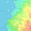
Porspoder topographic maps

Click on a map to view its topography, its elevation and its terrain.

Mezou Milin Avel

France > Bretagne > Finistère > Porspoder

Average elevation: 17 m

Spernoc

France > Bretagne > Finistère > Porspoder

Average elevation: 23 m

Mezou Poullané

France > Bretagne > Finistère > Porspoder

Average elevation: 21 m

Kerveoc

France > Bretagne > Finistère > Porspoder

Average elevation: 15 m

Le Vourch

France > Bretagne > Finistère > Porspoder > Le Vourch

Average elevation: 16 m

Keravel

France > Bretagne > Finistère > Porspoder

Average elevation: 17 m

About this place

 •

Gear up for your next adventure:

🗺️Topographic Maps - Detailed maps to explore trails, mountains, and wilderness areas
🧥Waterproof Hiking Jacket - Protect yourself from rain and wind while hiking
🧊Insulated Water Bottle - Keeps drinks cold in summer and prevents freezing in winter
🚲Bike Repair Kit - Essential tools for on-trail mechanical issues
🎒Hiking Daypack - Lightweight and durable backpacks for day trips and excursions

As an Amazon Associate, this site earns from qualifying purchases at no extra cost to you.