

Hermosillo topographic maps
Click on a map to view its topography, its elevation and its terrain.
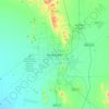
Hermosillo
Mexico > Sonora > Hermosillo > Hermosillo
The Cerro de la Campana mountain is one of the symbols of Hermosillo. Its summit is 350 metres (1,150 ft) above the valley floor and contains a lookout called El Caracol, which was inaugurated in 1909. There are two theories as to the origin of the mountain's name. One states that it is from a peculiar…
Average elevation: 248 m