Geolocate

Pioggiola topographic maps

Click on a map to view its topography, its elevation and its terrain.
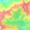
Pioggiola

France > Corse > Haute-Corse > Pioggiola > Pioggiola

Avec une superficie de 18,59 km2, Pioggiola est la troisième des quatre communes du Giussani dont elle occupe la partie nord-ouest. Son territoire est une longue bande de terre orientée dans un axe SO - NE. Il se situe au nord du massif du monte Cinto, à l'adret de la partie septentrionale de la chaîne…

Average elevation: 943 m

About this place

Gear up for your next adventure:

🚲Bike Repair Kit - Essential tools for on-trail mechanical issues
🧶550 Survival Paracord - Versatile utility cord for emergency repairs and rigging
🧭Orienteering Kit - Tools for map reading and navigation in the wild
🥫Freeze-Dried Meals - Lightweight, high-calorie nutrition for multi-day treks
🦶Anti-Blister Balm - Prevents friction and hotspots during long ascents

As an Amazon Associate, this site earns from qualifying purchases at no extra cost to you.