
The Bahamas topographic map
Interactive map
Click on the map to display elevation.
About this map
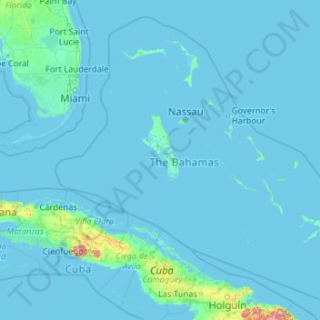
Name: The Bahamas topographic map, elevation, terrain.
Location: The Bahamas (20.70598 -80.70019 27.47346 -72.44775)
Average elevation: 9 m
Minimum elevation: -4 m
Maximum elevation: 1,111 m
According to the Köppen climate classification, the climate of The Bahamas is mostly tropical savannah climate or Aw, with a hot and wet season and a warm and dry season. The low latitude, warm tropical Gulf Stream, and low elevation give The Bahamas a warm and winterless climate.
Other topographic maps
Click on a map to view its topography, its elevation and its terrain.
Water Cay
The Bahamas > East Grand Bahama
Water Cay, East Grand Bahama, The Bahamas
Average elevation: 0 m
Emerald Ridge
Emerald Ridge, New Providence, The Bahamas
Average elevation: 7 m
Anderson Settlement
The Bahamas > Anderson Settlement
Anderson Settlement, The Bahamas
Average elevation: 3 m
Grand Bahama
The Bahamas > East Grand Bahama
Grand Bahama, East Grand Bahama, The Bahamas
Average elevation: 1 m
Village Green
The Bahamas > Village Green > New Providence
Village Green, New Providence, The Bahamas
Average elevation: 7 m