
Monument Valley topographic map
Interactive map
Click on the map to display elevation.
About this map
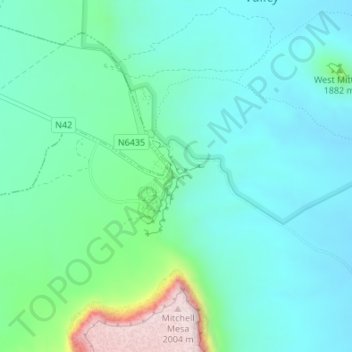
Name: Monument Valley topographic map, elevation, terrain.
Average elevation: 1,675 m
Minimum elevation: 1,585 m
Maximum elevation: 2,009 m
The area is part of the Colorado Plateau. The elevation of the valley floor ranges from 5,000 to 6,000 feet (1,500 to 1,800 m) above sea level. The floor is largely siltstone of the Cutler Group, or sand derived from it, deposited by the meandering rivers that carved the valley. The valley's vivid red color comes from iron oxide exposed in the weathered siltstone. The darker, blue-gray rocks in the valley get their color from manganese oxide.
Other topographic maps
Click on a map to view its topography, its elevation and its terrain.
Jeddito
United States > Arizona > Navajo County
Jeddito, Fort Defiance Agency, Navajo County, Arizona, United States
Average elevation: 1,939 m
First Mesa
United States > Arizona > Navajo County
First Mesa, Navajo County, Arizona, United States
Average elevation: 1,768 m
Winslow
United States > Arizona > Navajo County
Winslow, Navajo County, Arizona, United States
Average elevation: 1,495 m
Heber
United States > Arizona > Navajo County
Heber, Navajo County, Arizona, 85928, United States
Average elevation: 2,001 m