
Winslow topographic map
Interactive map
Click on the map to display elevation.
About this map
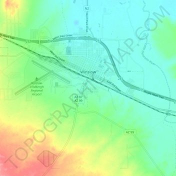
Name: Winslow topographic map, elevation, terrain.
Location: Winslow, Navajo County, Arizona, United States (34.98048 -110.75069 35.05334 -110.65353)
Average elevation: 1,495 m
Minimum elevation: 1,470 m
Maximum elevation: 1,553 m
Other topographic maps
Click on a map to view its topography, its elevation and its terrain.
Jeddito
United States > Arizona > Navajo County
Jeddito, Fort Defiance Agency, Navajo County, Arizona, United States
Average elevation: 1,939 m
Monument Valley
United States > Arizona > Navajo County
Monument Valley, Western Navajo Agency, Navajo County, Arizona, United States
Average elevation: 1,675 m
First Mesa
United States > Arizona > Navajo County
First Mesa, Navajo County, Arizona, United States
Average elevation: 1,768 m
Heber
United States > Arizona > Navajo County
Heber, Navajo County, Arizona, 85928, United States
Average elevation: 2,001 m