
Greiz topographic map
Interactive map
Click on the map to display elevation.
About this map
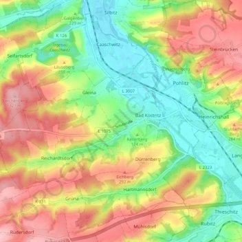
Name: Greiz topographic map, elevation, terrain.
Location: Bad Köstritz, Greiz, Thuringia, Germany (50.90049 11.94940 50.95672 12.04949)
Average elevation: 245 m
Minimum elevation: 173 m
Maximum elevation: 328 m
Other topographic maps
Click on a map to view its topography, its elevation and its terrain.
Lehnberg
Germany > Thuringia > Landkreis Nordhausen > Harztor > Herrmannsacker
Average elevation: 406 m
Eisenach
Germany > Thuringia > Eisenach
Eisenach is situated at the northern edge of the Thuringian Forest, at an elevation of about 220 m. The terrain is hilly, to the south also mountainous (up to 460 m of elevation), with the central Hörsel valley crossing the town in east-western direction. The Nesse river enters the Hörsel river in Eisenach…
Average elevation: 290 m