
Greiz topographic map
Interactive map
Click on the map to display elevation.
About this map
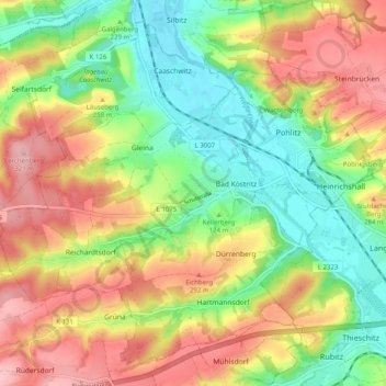
Name: Greiz topographic map, elevation, terrain.
Location: Bad Köstritz, Greiz, Thuringia, Germany (50.90049 11.94940 50.95672 12.04949)
Average elevation: 245 m
Minimum elevation: 173 m
Maximum elevation: 328 m
Other topographic maps
Click on a map to view its topography, its elevation and its terrain.
Hütscheroda
Germany > Thuringia > Wartburgkreis
Hütscheroda, Hörselberg-Hainich, Wartburgkreis, Thuringia, 99820, Germany
Average elevation: 356 m
Königsee
Germany > Thuringia > Landkreis Saalfeld-Rudolstadt > Königsee
Königsee, Landkreis Saalfeld-Rudolstadt, Thuringia, Germany
Average elevation: 434 m
Oberhasel
Germany > Thuringia > Uhlstädt-Kirchhasel > Oberhasel
Oberhasel, Uhlstädt-Kirchhasel, Kamsdorf, Landkreis Saalfeld-Rudolstadt, Thuringia, 07407, Germany
Average elevation: 272 m
Großer Hermannstein
Großer Hermannstein, Hermannsteiner Weg, Ilmenau, Ilm-Kreis, Thuringia, 98693, Germany
Average elevation: 661 m
Schloss
Germany > Thuringia > Bad Köstritz
Schloss, Julius-Sturm-Platz, Pohlitz, Bad Köstritz, Greiz, Thuringia, 07586, Germany
Average elevation: 207 m
Silberthal
Germany > Thuringia > Silberthal
Silberthal, Bürgel, Saale-Holzland-Kreis, Thuringia, 07616, Germany
Average elevation: 295 m
Eisenach
Germany > Thuringia > Wartburgkreis
Eisenach, Wartburgkreis, Thuringia, 99817, Germany
Average elevation: 298 m