
City of Banyule topographic map
Interactive map
Click on the map to display elevation.
About this map
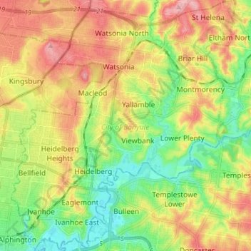
Name: City of Banyule topographic map, elevation, terrain.
Location: City of Banyule, Victoria, Australia (-37.78509 145.02783 -37.68263 145.14365)
Average elevation: 67 m
Minimum elevation: 10 m
Maximum elevation: 136 m
Other topographic maps
Click on a map to view its topography, its elevation and its terrain.
Narre Warren North Retarding Basin (Melbourne Water)
Australia > Victoria > Melbourne
Average elevation: 76 m