Geolocate

Ad Dakhiliyah Governorate topographic map

Interactive map

Click on the map to display elevation.

About this map

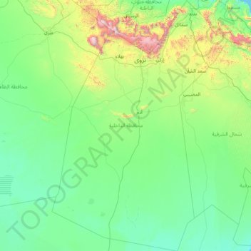
Name: Ad Dakhiliyah Governorate topographic map, elevation, terrain.

Location: Ad Dakhiliyah Governorate, Oman (20.90857 56.52715 23.55060 58.52517)

Average elevation: 315 m

Minimum elevation: 0 m

Maximum elevation: 2,943 m

Other topographic maps

Click on a map to view its topography, its elevation and its terrain.

Bahlā

Oman > Ad Dakhiliyah Governorate

Bahlā, Ad Dakhiliyah Governorate, 617, Oman

Average elevation: 670 m

جزماء الجديده

Oman > Al Batinah North Governorate

جزماء الجديده, Al Batinah North Governorate, 315, Oman

Average elevation: 8 m

Al Basatin

Oman > Ad Dhahirah Governorate

Al Basatin, Ad Dhahirah Governorate, Oman

Average elevation: 1,065 m

Muscat

Oman > Muscat > مسقط

Muscat, مسقط, Muscat, Oman

Average elevation: 134 m

Shamal Madinat as Saadah

Oman > Dhofar > Salalah

Shamal Madinat as Saadah, Salalah, Dhofar, Oman

Average elevation: 32 m

Musandam Governorate

Oman

Musandam Governorate, Oman

Average elevation: 69 m

Ras Sajir

Oman > Dhofar

Ras Sajir, Dhofar, Oman

Average elevation: 159 m

Strait of Hormuz

Oman

Strait of Hormuz, Oman

Average elevation: 75 m

Al Hajar Mountains

Oman > Al Batinah South > Ar Rustaq

Al Hajar Mountains, Ar Rustaq, Al Batinah South, Oman

Average elevation: 2,502 m

Masirah

Oman > Ash Sharqiyah > Masirah

Masirah, Ash Sharqiyah, Oman

Average elevation: 11 m

Al Hajar

Oman > Al Buraymi > البريمي

Al Hajar, البريمي, Al Buraymi, Oman

Average elevation: 782 m