
Dauphin Lake topographic map
Interactive map
Click on the map to display elevation.
About this map
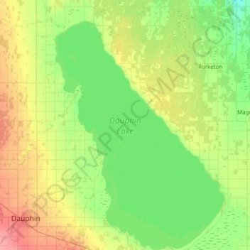
Name: Dauphin Lake topographic map, elevation, terrain.
Location: Dauphin Lake, Dauphin, Manitoba, Canada (51.10417 -100.00000 51.48737 -99.55571)
Average elevation: 267 m
Minimum elevation: 247 m
Maximum elevation: 309 m
Manitoba trails, hiking, mountain biking, running and outdoor activities
Other topographic maps
Click on a map to view its topography, its elevation and its terrain.
Riding Mountain National Park
The climate in the Riding Mountain region is similar to that of other regions of southwestern Manitoba. Under the Köppen classification it has a continental climate. It includes grasslands, upland boreal and eastern deciduous forest ecosystems. The park has hot summers and cold winters, with annual rainfall…
Average elevation: 488 m