
Make a donation
Gear up for your next adventure:
As an Amazon Associate, this site earns from qualifying purchases at no extra cost to you.
Lake Nipissing topographic map
Click on the map to display elevation.
Make a donation
Gear up for your next adventure:
As an Amazon Associate, this site earns from qualifying purchases at no extra cost to you.
Lake Nipissing
Lake Nipissing (/ˈnɪpəsɪŋ/; French: lac Nipissing, Ojibwe: Gichi-nibiinsing-zaaga’igan) is a lake in the Canadian province of Ontario. It has a surface area of 873.3 km2 (337.2 sq mi), a mean elevation of 196 m (643 ft) above sea level, and is located between the Ottawa River and Georgian Bay. Lake Nipissing is the third-largest lake entirely in Ontario. It is relatively shallow for a large lake, with an average depth of only 4.5 m (15 ft). The shallowness of the lake makes for many sandbars along the lake's irregular shoreline. The lake reaches a maximum depth of 64 m (210 ft) near the mouth of the French River, off the shore of Blueberry Island. The lake has many islands most of which are protected under the Protection of Significant Wetlands scheme, controlled by the Ministry of Natural Resources and Forestry.
Make a donation
Gear up for your next adventure:
As an Amazon Associate, this site earns from qualifying purchases at no extra cost to you.
About this map
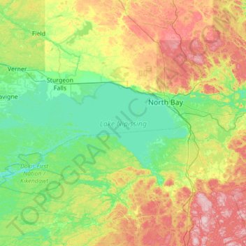
Name: Lake Nipissing topographic map, elevation, terrain.
Average elevation: 272 m
Minimum elevation: 182 m
Maximum elevation: 500 m
Nipissing District trails, hiking, mountain biking, running and outdoor activities
Make a donation
Gear up for your next adventure:
As an Amazon Associate, this site earns from qualifying purchases at no extra cost to you.
Other topographic maps
Click on a map to view its topography, its elevation and its terrain.
Make a donation
Gear up for your next adventure:
As an Amazon Associate, this site earns from qualifying purchases at no extra cost to you.
Windermere Lake
Canada > Ontario > Nipissing District > Unorganized South Nipissing
Average elevation: 355 m
Make a donation
Gear up for your next adventure:
As an Amazon Associate, this site earns from qualifying purchases at no extra cost to you.
Arrow Lake
Canada > Ontario > Nipissing District > Unorganized South Nipissing
Average elevation: 414 m
Thistle Lake
Canada > Ontario > Nipissing District > Unorganized South Nipissing
Average elevation: 459 m
Make a donation
Gear up for your next adventure:
As an Amazon Associate, this site earns from qualifying purchases at no extra cost to you.
William Lake
Canada > Ontario > Nipissing District > Unorganized South Nipissing
Average elevation: 421 m
Make a donation
Gear up for your next adventure:
As an Amazon Associate, this site earns from qualifying purchases at no extra cost to you.
Gilmour Lake
Canada > Ontario > Nipissing District > Papineau-Cameron Township
Average elevation: 342 m
Smoke Lake
Canada > Ontario > Nipissing District > Unorganized South Nipissing
Average elevation: 439 m
Make a donation
Gear up for your next adventure:
As an Amazon Associate, this site earns from qualifying purchases at no extra cost to you.
Carcajou Lake
Canada > Ontario > Nipissing District > Unorganized South Nipissing
Average elevation: 291 m
Make a donation
Gear up for your next adventure:
As an Amazon Associate, this site earns from qualifying purchases at no extra cost to you.
Bellwood
Canada > Ontario > Nipissing District > South Algonquin Township > Whitney
Average elevation: 410 m
Rose Lake
Canada > Ontario > Nipissing District > Unorganized South Nipissing
Average elevation: 459 m
Make a donation
Gear up for your next adventure:
As an Amazon Associate, this site earns from qualifying purchases at no extra cost to you.
Make a donation
Gear up for your next adventure:
As an Amazon Associate, this site earns from qualifying purchases at no extra cost to you.
Head Lake
Canada > Ontario > Nipissing District > Unorganized South Nipissing
Average elevation: 445 m
Mizzy Lake
Canada > Ontario > Nipissing District > Unorganized South Nipissing
Average elevation: 459 m
Rutherglen
Canada > Ontario > Nipissing District > Bonfield Township > Rutherglen
Average elevation: 236 m
Make a donation
Gear up for your next adventure:
As an Amazon Associate, this site earns from qualifying purchases at no extra cost to you.
Princes Lake
Canada > Ontario > Nipissing District > South Algonquin Township
Average elevation: 467 m
Madawaska Highlands
Canada > Ontario > Nipissing District > South Algonquin Township
Average elevation: 442 m
Make a donation
Gear up for your next adventure:
As an Amazon Associate, this site earns from qualifying purchases at no extra cost to you.
Whitelily Lake
Canada > Ontario > Nipissing District > South Algonquin Township
Average elevation: 389 m
Gilmour Island
Canada > Ontario > Nipissing District > Unorganized South Nipissing
Average elevation: 339 m
Coldspring Lake
Canada > Ontario > Nipissing District > Unorganized South Nipissing
Average elevation: 440 m
Make a donation
Gear up for your next adventure:
As an Amazon Associate, this site earns from qualifying purchases at no extra cost to you.
Beau Lake
Canada > Ontario > Nipissing District > Unorganized South Nipissing
Average elevation: 416 m