Geolocate

Notre-Dame-de-Pontmain topographic map

Interactive map

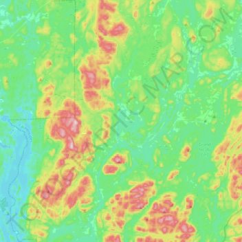
Click on the map to display elevation.

About this map

Name: Notre-Dame-de-Pontmain topographic map, elevation, terrain.

Location: Notre-Dame-de-Pontmain, Antoine-Labelle, Laurentides, Quebec, J0W 1S0, Canada (46.17034 -75.81457 46.43882 -75.53400)

Average elevation: 263 m

Minimum elevation: 160 m

Maximum elevation: 524 m

Antoine-Labelle trails, hiking, mountain biking, running and outdoor activities

Other topographic maps

Click on a map to view its topography, its elevation and its terrain.

Lac Prévost

Canada > Quebec > Antoine-Labelle > Lac-Ernest

Average elevation: 369 m

Lac La Force

Canada > Quebec > Antoine-Labelle > Lac-Douaire

Average elevation: 506 m

Lac-Bazinet

Canada > Quebec > Antoine-Labelle

Average elevation: 483 m

Lac Palma

Canada > Quebec > Antoine-Labelle > Lac-Bazinet

Average elevation: 571 m

Ruisseau Lanthier

Canada > Quebec > Antoine-Labelle > L'Ascension

Average elevation: 377 m

Île Papineau

Canada > Quebec > Antoine-Labelle > Mont-Laurier

Average elevation: 282 m