
Port-Cartier topographic map
Interactive map
Click on the map to display elevation.
About this map
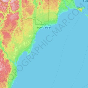
Name: Port-Cartier topographic map, elevation, terrain.
Location: Port-Cartier, Sept-Rivières, Côte-Nord, Quebec, Canada (49.58726 -67.48825 50.21210 -66.72403)
Average elevation: 77 m
Minimum elevation: -4 m
Maximum elevation: 539 m
Other topographic maps
Click on a map to view its topography, its elevation and its terrain.
Lac Serpent
Canada > Quebec > Sept-Rivières > Lac-Walker
Lac Serpent, Lac-Walker, Sept-Rivières, Côte-Nord, Quebec, Canada
Average elevation: 476 m
Lac Louisa
Canada > Quebec > Sept-Rivières > Lac-Walker
Lac Louisa, Lac-Walker, Sept-Rivières, Côte-Nord, Quebec, Canada
Average elevation: 201 m
Sept-Îles
Canada > Quebec > Sept-Rivières
Sept-Îles, Sept-Rivières, Côte-Nord, Quebec, Canada
Average elevation: 189 m
Sept-Îles
Canada > Quebec > Sept-Rivières > Sept-Îles
Sept-Îles, Sept-Rivières, Côte-Nord, Quebec, G4R 1X5, Canada
Average elevation: 65 m
Lac Jaune
Canada > Quebec > Sept-Rivières > Lac-Walker
Lac Jaune, Lac-Walker, Sept-Rivières, Côte-Nord, Quebec, Canada
Average elevation: 150 m