
Wetaskiwin topographic map
Interactive map
Click on the map to display elevation.
Wetaskiwin
The city lies at an elevation of 760 m (2,490 ft). Coal Lake, a reservoir developed on the Battle River is located immediately east of the city, and other nearby waterways include Pipestone Creek, Bigstone Creek, Bittern Lake and Bearhills Lake.
About this map
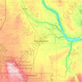
Name: Wetaskiwin topographic map, elevation, terrain.
Location: Wetaskiwin, City of Wetaskiwin, Alberta, T9A 0T5, Canada (52.80849 -113.52792 53.12849 -113.20792)
Average elevation: 770 m
Minimum elevation: 693 m
Maximum elevation: 867 m
Alberta trails, hiking, mountain biking, running and outdoor activities