Geolocate

Yarmouth topographic map

Click on the map to display elevation.

About this map

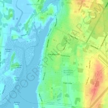
Name: Yarmouth topographic map, elevation, terrain.

Location: Yarmouth, Yarmouth County, Nova Scotia, Canada (43.81748 -66.13402 43.85721 -66.08856)

Average elevation: 17 m

Minimum elevation: -6 m

Maximum elevation: 51 m

Yarmouth County trails, hiking, mountain biking, running and outdoor activities

Other topographic maps

Click on a map to view its topography, its elevation and its terrain.

Somes Lake

Canada > Nova Scotia > Yarmouth County > Canaan

Average elevation: 23 m

Gear up for your next adventure:

🧭Orienteering Kit - Tools for map reading and navigation in the wild
🧴Waterproofing Spray - Restore the DWR coating on jackets and tents
🦶Hiking Shoe Insoles - Added support for high arches and long days on feet
🦯Trekking Poles - Reduced impact on joints for steep topographic climbs
🛌Down Sleeping Bag - Superior warmth-to-weight ratio for cold nights

As an Amazon Associate, this site earns from qualifying purchases at no extra cost to you.