
Fullerton topographic map
Interactive map
Click on the map to display elevation.
Fullerton
Fullerton is located at 33°52′48″N 117°55′43″W / 33.88000°N 117.92861°W / 33.88000; -117.92861 (33.879914, -117.928749). It is approximately 25 miles (40 km) southeast of downtown Los Angeles, and approximately 11 miles (18 km) north-northwest of Santa Ana, the county seat. The city has a mean elevation of 150 feet (46 m) and lies approximately 11 miles (18 km) northeast of the Pacific Ocean straight-line distance. It has a Mediterranean climate, with a mean temperature of 62.2 °F (16.8 °C).
About this map
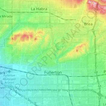
Name: Fullerton topographic map, elevation, terrain.
Location: Fullerton, Orange County, California, United States (33.85416 -117.98542 33.92446 -117.86371)
Average elevation: 79 m
Minimum elevation: 25 m
Maximum elevation: 225 m
Other topographic maps
Click on a map to view its topography, its elevation and its terrain.
Rancho Mission Viejo Ecological Reserve
United States > California > Orange County
Average elevation: 160 m
Huntington Harbor
United States > California > Orange County > Huntington Beach > Huntington Harbor
Average elevation: 4 m
San Joaquin Hills
United States > California > Orange County > Newport Beach > San Joaquin Hills
Average elevation: 153 m
Huntington Beach
United States > California > Orange County > Huntington Beach
Average elevation: 16 m