
Tagaytay topographic map
Interactive map
Click on the map to display elevation.
About this map
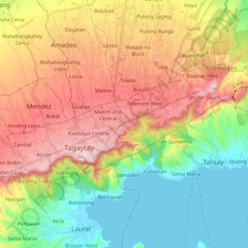
Name: Tagaytay topographic map, elevation, terrain.
Location: Tagaytay, Cavite, Calabarzon, 4120, Philippines (14.07911 120.88591 14.15765 121.05140)
Average elevation: 314 m
Minimum elevation: 3 m
Maximum elevation: 728 m
The southern and eastern portions of Tagaytay are covered by hills and mountains which is generally forests, pine trees and open grasslands. The city lies along Tagaytay Ridge, a ridge stretching about 32 kilometres (20 mi) from Mount Batulao in the west to Mount Sungay in the east with elevations averaging about 610 metres (2,000 ft) above sea level. Mount Sungay, in Tagaytay, is the highest point of the province of Cavite at 709 metres (2,326 ft).
Other topographic maps
Click on a map to view its topography, its elevation and its terrain.
Asisan
Philippines > Cavite > Tagaytay
Asisan, Tagaytay, Cavite, Calabarzon, 4120, Philippines
Average elevation: 526 m
Tagaytay
Philippines > Cavite > Tagaytay
Tagaytay, Cavite, Calabarzon, 4120, Philippines
Average elevation: 225 m