
Chino Valley topographic map
Interactive map
Click on the map to display elevation.
About this map
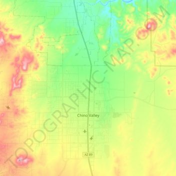
Name: Chino Valley topographic map, elevation, terrain.
Average elevation: 1,454 m
Minimum elevation: 1,288 m
Maximum elevation: 1,700 m
The town is in north-central Arizona, on state Highway 89, 15 miles (24 km) north of Prescott and 35 miles (56 km) south of Ash Fork, which is on Interstate 40. Chino Valley is at an elevation of about 4,750 feet (1,450 m).
Other topographic maps
Click on a map to view its topography, its elevation and its terrain.
Prescott
United States > Arizona > Yavapai County
Prescott, Yavapai County, Arizona, United States
Average elevation: 1,674 m
Black Canyon City
United States > Arizona > Yavapai County
Black Canyon City, Yavapai County, Arizona, 85324, United States
Average elevation: 763 m
Ash Fork
United States > Arizona > Yavapai County > Ash Fork
Ash Fork, Yavapai County, Arizona, 86320, United States
Average elevation: 1,561 m
Cottonwood
United States > Arizona > Yavapai County
Cottonwood, Yavapai County, Arizona, United States
Average elevation: 1,118 m
Prescott Valley
United States > Arizona > Yavapai County
Prescott Valley, Yavapai County, Arizona, United States
Average elevation: 1,550 m
Sedona
United States > Arizona > Yavapai County
Sedona, Yavapai County, Arizona, 86336, United States
Average elevation: 1,342 m