
Prescott Valley topographic map
Click on the map to display elevation.
Prescott Valley
Prescott Valley (locally, PV) is located in central Arizona approximately 85 miles (137 km) north of Phoenix at 5,100 feet (1,600 m). elevation. PV has good access to Arizona State Route 89, SR-89A and SR-69, connecting to Interstates 17 and 40. Air service is available at Ernest A. Love Field, approximately 8 miles (13 km) northwest.
About this map
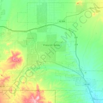
Name: Prescott Valley topographic map, elevation, terrain.
Location: Prescott Valley, Yavapai County, Arizona, United States (34.52784 -112.38624 34.67262 -112.20168)
Average elevation: 1,550 m
Minimum elevation: 1,378 m
Maximum elevation: 1,972 m
Other topographic maps
Click on a map to view its topography, its elevation and its terrain.
Chino Valley
United States > Arizona > Yavapai County
The town is in north-central Arizona, on state Highway 89, 15 miles (24 km) north of Prescott and 35 miles (56 km) south of Ash Fork, which is on Interstate 40. Chino Valley is at an elevation of about 4,750 feet (1,450 m).
Average elevation: 1,454 m