Geolocate

Cockeysville topographic map

Interactive map

Click on the map to display elevation.

About this map

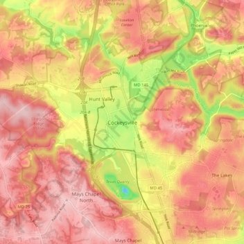
Name: Cockeysville topographic map, elevation, terrain.

Location: Cockeysville, Baltimore County, Maryland, 21031, United States (39.44457 -76.69028 39.52457 -76.61028)

Average elevation: 131 m

Minimum elevation: -8 m

Maximum elevation: 200 m

Other topographic maps

Click on a map to view its topography, its elevation and its terrain.

Kingsville

United States > Maryland > Baltimore County

Kingsville, Baltimore County, Maryland, 21087, United States

Average elevation: 83 m

Turkey Point Park

United States > Maryland > Baltimore County > Dundalk > Turkey Point

Turkey Point Park, Bauernschmidt Manor, Turkey Point, Dundalk, Baltimore County, Maryland, United States

Average elevation: 2 m

Dundalk

United States > Maryland > Baltimore County

Dundalk, Baltimore County, Maryland, 21222, United States

Average elevation: 33 m

Bird River

United States > Maryland > Baltimore County > Bowleys Quarters

Bird River, Bowleys Quarters, Baltimore County, Maryland, United States

Average elevation: 4 m

Timonium

United States > Maryland > Baltimore County

Timonium, Baltimore County, Maryland, 21093, United States

Average elevation: 118 m

Owings Mills

United States > Maryland > Baltimore County > Owings Mills

Owings Mills, Baltimore County, Maryland, 21117, United States

Average elevation: 173 m

White Marsh

United States > Maryland > Baltimore County > White Marsh

White Marsh, Baltimore County, Maryland, United States

Average elevation: 39 m

Arbutus

United States > Maryland > Baltimore County > Relay

Arbutus, Relay, Baltimore County, Maryland, United States

Average elevation: 42 m

Woodlawn

United States > Maryland > Baltimore County

Woodlawn, Baltimore County, Maryland, 21241, United States

Average elevation: 123 m

Lansdowne

United States > Maryland > Baltimore County > Lansdowne

Lansdowne, Baltimore County, Maryland, United States

Average elevation: 24 m

Essex

United States > Maryland > Baltimore County > Essex

Essex, Baltimore County, Maryland, 21221, United States

Average elevation: 6 m

Dundalk

United States > Maryland > Baltimore County > Dundalk

Dundalk, Baltimore County, Maryland, 21222, United States

Average elevation: 6 m

Shawan

United States > Maryland > Baltimore County > Towson

Shawan, Towson, Baltimore County, Maryland, 21023, United States

Average elevation: 160 m

Phoenix

United States > Maryland > Baltimore County

Phoenix, Baltimore County, Maryland, 21030, United States

Average elevation: 123 m

Middle River

United States > Maryland > Baltimore County > Middle River

Middle River, Baltimore County, Maryland, 21220, United States

Average elevation: 13 m

Herring Run Park

United States > Maryland > Baltimore County > Rosedale

Herring Run Park, Rosedale, Baltimore County, Maryland, United States

Average elevation: 37 m

Towson

United States > Maryland > Baltimore County > Towson

Towson, Baltimore County, Maryland, United States

Average elevation: 114 m

Island View Beach

United States > Maryland > Baltimore County > Island View Beach

Island View Beach, Baltimore County, Maryland, United States

Average elevation: 3 m

Milford Mill

United States > Maryland > Baltimore County > Milford Mill

Milford Mill, Baltimore County, Maryland, 21244, United States

Average elevation: 142 m

Quarry Lake

United States > Maryland > Baltimore County > Pikesville

Quarry Lake, Pikesville, Baltimore County, Maryland, United States

Average elevation: 137 m

Catonsville

United States > Maryland > Baltimore County > Catonsville

Catonsville, Baltimore County, Maryland, United States

Average elevation: 105 m