
Saint-Sixte topographic map
Interactive map
Click on the map to display elevation.
About this map
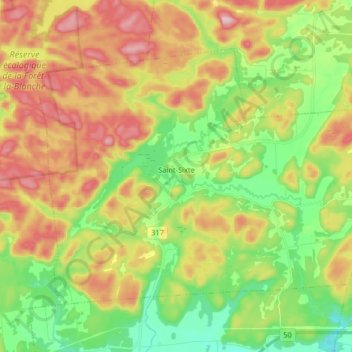
Name: Saint-Sixte topographic map, elevation, terrain.
Location: Saint-Sixte, Papineau, Outaouais, Quebec, Canada (45.65507 -75.27324 45.73801 -75.11029)
Average elevation: 196 m
Minimum elevation: 76 m
Maximum elevation: 352 m
Papineau trails, hiking, mountain biking, running and outdoor activities
Other topographic maps
Click on a map to view its topography, its elevation and its terrain.
Réserve écologique de la Forêt-la-Blanche
Canada > Quebec > Papineau > Mulgrave-et-Derry
Average elevation: 243 m