
Village of Spencerport topographic map
Interactive map
Click on the map to display elevation.
About this map
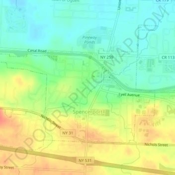
Name: Village of Spencerport topographic map, elevation, terrain.
Average elevation: 164 m
Minimum elevation: 142 m
Maximum elevation: 191 m
Other topographic maps
Click on a map to view its topography, its elevation and its terrain.
Town of Riga
United States > New York > Monroe County
Town of Riga, Monroe County, New York, 14428, United States
Average elevation: 185 m
Town of Irondequoit
United States > New York > Monroe County
Town of Irondequoit, Monroe County, New York, United States
Average elevation: 110 m
Belcoda
United States > New York > Monroe County
Belcoda, Town of Wheatland, Monroe County, New York, 14511, United States
Average elevation: 196 m
Town of Penfield
United States > New York > Monroe County
Town of Penfield, Monroe County, New York, United States
Average elevation: 135 m
Ellison Park
United States > New York > Monroe County > Penfield
Ellison Park, Brighton, Penfield, Monroe County, New York, United States
Average elevation: 112 m
Pittsford
United States > New York > Monroe County > Pittsford
Pittsford, Monroe County, New York, United States
Average elevation: 147 m
Town of Webster
United States > New York > Monroe County
Town of Webster, Monroe County, New York, 14580, United States
Average elevation: 111 m
City of Rochester
United States > New York > Monroe County
City of Rochester, Monroe County, New York, United States
Average elevation: 129 m