
Province of Morropón topographic map
Interactive map
Click on the map to display elevation.
About this map
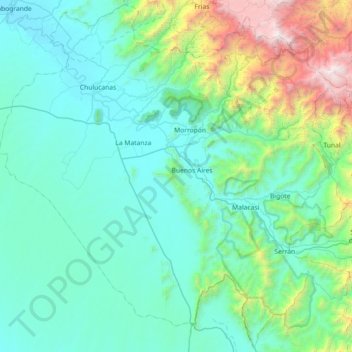
Name: Province of Morropón topographic map, elevation, terrain.
Location: Province of Morropón, Piura, Peru (-5.63003 -80.36502 -4.92783 -79.64221)
Average elevation: 603 m
Minimum elevation: 60 m
Maximum elevation: 3,662 m
This province is located in the center of the Piura Region, being a land of contrast and climatic fusion. It is dotted by tropical forests of the dry-equatorial style in its flat areas were the carob tree predominates. In high areas of an elevation 1,500 to 2,000 metres (4,900–6,600 ft) the landscape changes to smooth high jungle and a lack of varied hilly valleys.
Other topographic maps
Click on a map to view its topography, its elevation and its terrain.
Lucarqui
Peru > Piura > Distrito de Ayabaca
Lucarqui, Distrito de Ayabaca, Province of Ayabaca, Piura, Peru
Average elevation: 1,862 m
Parque Miguel Cortés
Parque Miguel Cortés, Urbanización 4 de Enero, Piura, Province of Piura, Piura, Peru
Average elevation: 32 m
Cerro Vicús
Peru > Piura > Chulucanas
Cerro Vicús, Chulucanas, Morropón, Piura, Peru
Average elevation: 171 m
Aypate
Peru > Piura > Distrito de Ayabaca
Aypate, PE-3N, Distrito de Ayabaca, Ayabaca, Piura, Peru
Average elevation: 2,568 m