
Sioux City topographic map
Interactive map
Click on the map to display elevation.
Sioux City
Sioux City is located at 42°29′44″N 96°23′26″W / 42.495668°N 96.390525°W / 42.495668; -96.390525.[1] Sioux City lies at an altitude of 1,135 ft (345.9 m) above sea level. Sioux City borders two states, South Dakota to the west-northwest and Nebraska to the west. According to the United States Census Bureau, the city has a total area of 59.63 sq mi (154.44 km2), of which 58.46 sq mi (151.41 km2) is land and 1.165 sq mi (3.02 km2) is water.[1]
About this map
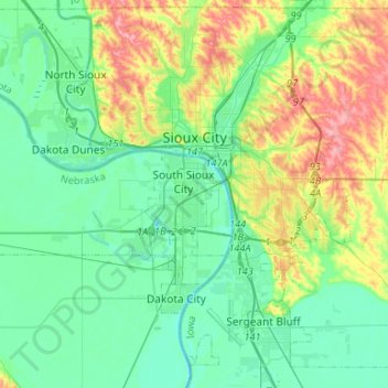
Name: Sioux City topographic map, elevation, terrain.
Location: Sioux City, Woodbury County, Iowa, United States (42.37007 -96.49899 42.56542 -96.29956)
Average elevation: 352 m
Minimum elevation: 319 m
Maximum elevation: 438 m
Other topographic maps
Click on a map to view its topography, its elevation and its terrain.