
Biddeford topographic map
Interactive map
Click on the map to display elevation.
About this map
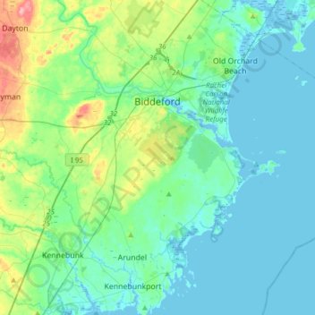
Name: Biddeford topographic map, elevation, terrain.
Location: Biddeford, York County, Maine, 04005, United States (43.35976 -70.56528 43.54548 -70.25931)
Average elevation: 21 m
Minimum elevation: -6 m
Maximum elevation: 110 m
Other topographic maps
Click on a map to view its topography, its elevation and its terrain.
temp
United States > Maine > York County > Hollis
temp, Hollis, York County, Maine, 04042, United States
Average elevation: 103 m
York
United States > Maine > York County
York, York County, Maine, United States
Average elevation: 18 m
Kittery
United States > Maine > York County
Kittery, York County, Maine, United States
Average elevation: 8 m
Newfield
United States > Maine > York County
Newfield, York County, Maine, 04095, United States
Average elevation: 155 m
Mill Brook
United States > Maine > York County > Old Orchard Beach
Mill Brook, Old Orchard Beach, York County, Maine, 04064, United States
Average elevation: 21 m