
Make a donation
Gear up for your next adventure:
As an Amazon Associate, this site earns from qualifying purchases at no extra cost to you.
Newfield topographic map
Click on the map to display elevation.
Make a donation
Gear up for your next adventure:
As an Amazon Associate, this site earns from qualifying purchases at no extra cost to you.
About this map
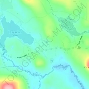
Name: Newfield topographic map, elevation, terrain.
Location: Newfield, York County, Maine, 04095, United States (43.64408 -70.88986 43.64418 -70.88976)
Average elevation: 155 m
Minimum elevation: 121 m
Maximum elevation: 262 m
Make a donation
Gear up for your next adventure:
As an Amazon Associate, this site earns from qualifying purchases at no extra cost to you.
Other topographic maps
Click on a map to view its topography, its elevation and its terrain.
York
United States > Maine > York County
According to the United States Census Bureau, the town has a total area of 131.78 square miles (341.31 km2), of which 54.67 square miles (141.59 km2) is land and 77.11 square miles (199.71 km2) is water. The York watershed drains into the York River. The highest point in town is Mount Agamenticus, with an…
Average elevation: 18 m
Make a donation
Gear up for your next adventure:
As an Amazon Associate, this site earns from qualifying purchases at no extra cost to you.