Geolocate

Pljevlja Municipality topographic map

Interactive map

Click on the map to display elevation.

About this map

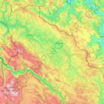
Name: Pljevlja Municipality topographic map, elevation, terrain.

Location: Pljevlja Municipality, 84210, Montenegro (43.06612 18.91244 43.55851 19.55042)

Average elevation: 1,154 m

Minimum elevation: 395 m

Maximum elevation: 2,460 m

Other topographic maps

Click on a map to view its topography, its elevation and its terrain.

Durmitor

Montenegro > Žabljak Municipality

Average elevation: 1,950 m

Kotor

Montenegro > Kotor Municipality

Average elevation: 280 m

Njeguši

Montenegro > Old Royal Capital Cetinje

Average elevation: 1,057 m

Crkvičko Polje

Montenegro > Plužine Municipality

Average elevation: 1,194 m

PL

Montenegro > Plav

Average elevation: 964 m

Kotor

Montenegro > Kotor

Average elevation: 567 m

Čelišta

Montenegro > Godinje

Average elevation: 114 m

Cetinje

Montenegro > Cetinje

Average elevation: 740 m

BOBOVO

Montenegro > BOBOVO

Average elevation: 1,419 m

Bijelo Polje

Montenegro > Bijelo Polje

Average elevation: 1,055 m