
San Juan topographic map
Interactive map
Click on the map to display elevation.
San Juan
In 2007, the same company installed the world's highest-situated wind turbine at the Veladero mine in San Juan Province at nearly 4,200m elevation.
About this map
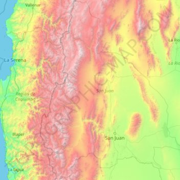
Name: San Juan topographic map, elevation, terrain.
Location: San Juan, Argentina (-32.62663 -70.56968 -28.38876 -66.66127)
Average elevation: 1,848 m
Minimum elevation: 0 m
Maximum elevation: 6,480 m
Other topographic maps
Click on a map to view its topography, its elevation and its terrain.
Andes
Argentina > Mendoza > Distrito Las Cuevas
The Andes Mountains are the highest mountain range outside Asia. The highest mountain outside Asia, Argentina's Mount Aconcagua, rises to an elevation of about 6,961 m (22,838 ft) above sea level. The peak of Chimborazo in the Ecuadorian Andes is farther from the Earth's center than any other location on the…
Average elevation: 6,208 m
Aconcagua
Argentina > Mendoza > Distrito Las Cuevas
Aconcagua (Spanish pronunciation: [akoŋˈkaɣwa]) is a mountain in the Principal Cordillera of the Andes mountain range, in Mendoza Province, Argentina. It is the highest mountain in the Americas, the highest outside Asia, and the highest in the Southern Hemisphere with a summit elevation of 6,961 metres…
Average elevation: 6,201 m
Piedra del Águila
Argentina > Neuquén Province > Municipio de Piedra del Águila
Average elevation: 539 m