
Keserwan District topographic map
Interactive map
Click on the map to display elevation.
About this map
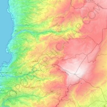
Name: Keserwan District topographic map, elevation, terrain.
Location: Keserwan District, Mount Lebanon Governorate, Lebanon (33.94017 35.59808 34.08619 35.99659)
Average elevation: 1,202 m
Minimum elevation: 0 m
Maximum elevation: 2,617 m
Other topographic maps
Click on a map to view its topography, its elevation and its terrain.
Faraya
Lebanon > Keserwan District > Faraya
Faraya, Keserwan District, Mount Lebanon Governorate, Lebanon
Average elevation: 1,846 m
Caza of Kesrouane
Caza of Kesrouane, Keserwan District, Mount Lebanon Governorate, 25349, Lebanon
Average elevation: 1,339 m