
Almonte topographic map
Interactive map
Click on the map to display elevation.
About this map
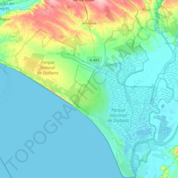
Name: Almonte topographic map, elevation, terrain.
Location: Almonte, El Condado, Huelva, Andalusia, Spain (36.79558 -6.73846 37.33057 -6.33101)
Average elevation: 23 m
Minimum elevation: -3 m
Maximum elevation: 154 m
Almonte is a town and municipality located in the province of Huelva, in southwestern Spain. According to the 2022 census, it had a population of 25,448 inhabitants, ranking third within its province, just after Huelva, the capital city and Lepe. With its 859.21 km2 (33174 sq mi), it is the 19th largest municipality in Spain, with a population density of 27/km2. Its elevation is 75 m (246 ft) over sea level and it is 50 km far from Huelva. Almonte is recognised worldwide thanks to the village of El Rocío, which had a great influence in the American Wild West culture and hosts one of the most popular pilgrimages in the world, most of the Doñana National Park, declared a World Heritage Site by UNESCO and the longest beach in Spain, which includes the popular Matalascañas beach. It is also one of Spain's top organic fruit exporter and the first blueberry exporter in Europe.