
Newport Beach topographic map
Interactive map
Click on the map to display elevation.
Newport Beach
Newport Beach extends in elevation from sea level to the 1161 ft (354 m.) summit of Signal Peak in the San Joaquin Hills, but the official elevation is 25 feet (8 m) above sea level at a location of 33°37′0″N 117°53′51″W / 33.61667°N 117.89750°W / 33.61667; -117.89750 (33.616671, −117.897604).
About this map
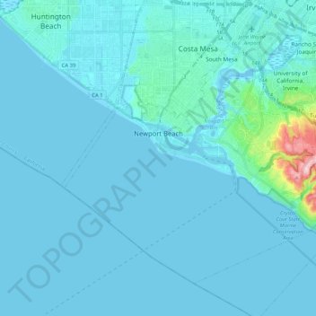
Name: Newport Beach topographic map, elevation, terrain.
Location: Newport Beach, Orange County, California, United States (33.53488 -117.99118 33.67175 -117.78390)
Average elevation: 14 m
Minimum elevation: -4 m
Maximum elevation: 231 m
Other topographic maps
Click on a map to view its topography, its elevation and its terrain.
Rancho Mission Viejo Ecological Reserve
United States > California > Orange County
Average elevation: 160 m
Huntington Harbor
United States > California > Orange County > Huntington Beach > Huntington Harbor
Average elevation: 4 m
San Joaquin Hills
United States > California > Orange County > Newport Beach > San Joaquin Hills
Average elevation: 153 m
Huntington Beach
United States > California > Orange County > Huntington Beach
Average elevation: 16 m