
Queenstown topographic map
Interactive map
Click on the map to display elevation.
About this map
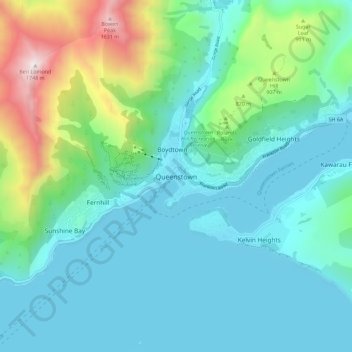
Name: Queenstown topographic map, elevation, terrain.
Average elevation: 592 m
Minimum elevation: 303 m
Maximum elevation: 1,729 m
The town is at a relatively low altitude for a ski and snowboarding centre, at 310 metres (1,020 ft) above sea level at the lake shore, but is nestled among mountains, most notably the scenic attraction of The Remarkables, to the town's southeast. Below the lake lies the deep Kawarau Gorge, and there are nearby plains suitable for agriculture and viticulture. Queenstown lies close to the heart of the Central Otago wine region.
Other topographic maps
Click on a map to view its topography, its elevation and its terrain.
Wānaka
New Zealand > Otago > Queenstown-Lakes District
Wānaka, Queenstown-Lakes District, Otago, 9305, New Zealand
Average elevation: 381 m
Cardrona
New Zealand > Otago > Queenstown-Lakes District
Cardrona, Queenstown-Lakes District, Otago, New Zealand
Average elevation: 758 m
Prince of Wales
New Zealand > Otago > Queenstown-Lakes District
Prince of Wales, Queenstown-Lakes District, Otago, New Zealand
Average elevation: 1,274 m